Showing posts with label glaciation. Show all posts

October 4, 2025

Bogged Down in Andover, and Loving Every Minute of It

On Saturday morning, I discovered just how much I still have to learn about horticulture. And the gaps in my knowledge of glaciation. And, even of apples. And I had fun doing it.

Double-click for a full-screen image

The Trustees of Reservations has more than 120 properties under its care. Those properties encompass nearly 29,000 acres in Massachusetts. Until Saturday, I was unaware of the existence of the Charles W. Ward Reservation. It is more than a square mile (729 acres to be exact) spread out across the towns of Andover and North Andover, some 30 miles north of Boston.

I was invited by Grow Native Massachusetts, about which I have written previously) to be part of their annual ‘Ramble’. Fifteen hardy souls with hiking shoes gathered outside a house on a hilltop – excuse me, a drumlin – to explore a nearby rare quaking bog.

That's Boston in the distance

The first thing I noticed was the view. A drumlin, for the uninitiated, is a glacial deposit. As the Ice Age passed its peak 11,000 years ago, rock-laden glaciers – once a mile thick - retreated north from the coast of what would become Massachusetts. Occasionally, part of a glacier would melt, leaving behind a pile of stones collected centuries earlier. One of those deposits became a 300-foot-high hill. Looking south, I had a clear view of Boston’s skyline, with seemingly only a forest between where I was standing and the city. The vista will stay in my mind for a long time.

A boardwalk through the bog

There are 13 miles of trails on the Reservation, but our specific destination was a hundred or so feet below us: a quaking bog in a kettle hole. Translation: as glaciers retreated, they also scraped the ground bare. Occasionally, they left a large, saucer-shaped stone depression called a kettle hole. Rain would fill the kettle hole to a maximum depth of a few feet and, at its fringes, vegetation would establish itself. Over the centuries, the vegetation would gradually grow deeper into the kettle hole, putting down an advancing layer of sediment in the form of rotted leaves and such. But with no outlet for water, the oxygen in the water became depleted and, where there is no oxygen, the sediment never breaks down; it just accumulates and solidifies – sort of.

One of our guides, in orange,
identifies bag-specific plants

The result is a bog. On top, there are trees, shrubs, ferns, moss (lots of moss), and ground covers. It is all quite dense and beautiful to look at. But stepping on it is a bad idea. What looks solid on top is largely an illusion. To that end, Trustees of Reservations built a winding boardwalk through the bog. Two experts – volunteers from the Trustees – led us deeper into the bog and identified the highly specialized plants that had learned to thrive in this most unusual of environments. I managed to confidently mis-identify more than a dozen plants and shrubs before I learned to listen rather than speak.

The ‘quaking’ part of the bog came as we approached its center: to Pine Hole Pond, an acre-sized pool of open water that remained un-colonized. Here, driving footers into the bog was pointless: there was nothing solid below the vegetation. So, everything floated, even though we were ostensibly amid dense vegetation. 

Pine Hole Pond, the last 'uncolonized' 
part of the bog

I managed to keep my footing, but there is something quite disturbing about feeling the ground under your feet ‘quake’ as you walk.

One of our guides, who has lived in the area most of his life, related the extent to which the bog pond is shrinking. He opined that it will disappear in a few decades. A warming climate emboldens species to grow more aggressively. More than 90% of the pond has been ‘colonized’ over the centuries. Pulling out vegetation might delay the inevitable, but not change the outcome.

We returned to the hilltop to enjoy the view and to discuss among ourselves what we had learned.

Our luncheon spot atop a drumlin;
a beautiful space forever preserved.

At the same time, I was curious how more than a square mile of prime land had managed never to be developed. Our guide provided the answer. A wealthy colonist, Nicholas Holt, purchased much of the land in the early 18th Century as a means of escaping the overly religious environment of Andover. Generations of his family farmed the site, leaving behind one of the most intact system of stone walls in the region. In the nineteen-teens, the Ward family acquired the estate; then about 500 acres. They were dedicated naturalists who sought to preserve the land and keep it in trust.

The first parcels were conveyed to Trustees of Reservations in 1940 with the death of Charles Ward. His family continued to gift additional parcels for the next 50 years, and Trustees purchased additional land to ‘fill in’ the Reservation. As the accompanying map shows, it is a remarkable achievement to have conserved such a large site so close to a major city.

Oh, and as to the apples, both the Holt and the Ward families had extensive apple orchards on the property. In the past decade, Trustees has sought to honor that legacy by planting small orchards. The apple variety chosen was the Baldwin, which was first identified in the Merrimack Valley in the 1850s. A few of the century-plus-old Baldwin trees are still producing. I confidently identified the apple as a Macintosh. I was gently corrected.

December 6, 2019

A Walk in the Pine Forest


Geology is destiny, and geology is a product of time plus luck.  I failed to absorb that lesson back in college, but it was finally made clear when I was recently part of a group taking a hike through the Myles Standish State Forest.
12,000 years ago, Massachusetts was
under a mile's thickness of ice.
Double-click for a full-screen slideshow
It took until the later half of the 19th Century for scientists to understand the role of ice-age glaciation.  Until that time, ‘Noah’s Flood’ (I promise I am not making this up) was the accepted source for the creation of everything from the Great Lakes to Cape Cod.  The notion that the top half of North America was under more than a mile of ice was something we humans couldn’t wrap our minds around. 
Glaciers, we gradually came to understand, advanced and ebbed over tens of thousands of years, finally retreating to the poles and high mountains about 11,000 years ago.  It was a messy business.  Acting as hundred-mile-wide bulldozers, glaciers pushed debris out in front of them, forming moraines when the sheet of ice reversed course.  Cape Cod is visible evidence of that final push, as is Long Island.  The glaciers’ retreat was quite uneven, with glacial remnants settling into low areas scraped out when the ice advanced hundreds or thousands of years earlier.  We call those pockets ‘kettles.’  If they have water, they’re ‘kettle ponds.’
Myles Standish State Forest  survived
as a native plant habitat because the
land was unsuitable for crops.
The inland part of Southeastern Massachusetts got the fuzzy end of the glacial lollipop.  Instead of dumping rocks and silt to break down into soil to support vegetation, the glaciers retreating from the area that is now Myles Standish State Forest left behind sand dozens of feet deep, plus more than its quota of kettle holes, where frost could be found 11 months of the year.
Which is all to say it was rotten farmland.  Settlers came, planted, saw their crops wither for lack of nutrition (sand is notably lacking in nutrients) and water (which just perked down to the aquifer in minutes), and left for greener pastures.  As a result of this benign neglect, the area is a near-perfect repository of the plants that would have been encountered when the first Europeans arrived.  It was pine forest plus scrubby vegetation in 1616, and so it was when the state forest was created 300 years later.
Bryan Connolly, left, provides
an introduction to the Pine Barrens
That near-pristine provenance is why I was part of a groups of about 15 amateurs and two experts walking fire trails through the forest – technically called the pine barrens – on a Saturday morning.  Our leaders were Bryan Connolly and Meredith Gallogly.  Bryan has many titles.  One of them is Assistant Professor at Framingham State University (sadly, being a full-time native plant naturalist requires multiple part-time gigs).  He is also one of the authors of ‘The Yellow Book’; an exhaustive index by region of plants native to the Commonwealth.  Meredith has the good fortune to be the Manager of Programs for an organization called Grow Native Massachusetts, more about which in a moment.  She is one of the group’s two employees.
This kettle, about seven acres in size, has frost 11 months of the year
We, the amateurs, walked and tried to keep up – physically and intellectually – with our two professionals who spoke largely in Latin binomials.  We started with the overview: Myles Standish State Forest encompasses 12,400 acres (19 square miles) of pine barrens; the third largest such preserve in the world.  Apart from some ill-conceived efforts to plant ‘useful’ (read: commercially harvestable) red pines by the Works Progress Administration in the 1930s, the land is as it was when the Wampanoag were its residents.  The red pines, incidentally, have almost all vanished, leaving behind the native pitch pine that somehow finds sustenance in the sand.  We learned the pines need to burn periodically to reproduce, and forest managers periodically burn areas of the barrens to ensure the next generation of trees.
The really good stuff, though, was underfoot.  What might appear to the uninitiated as ‘weeds’ and ‘brush’ was instead a Noah’s Ark of native plants plus a few uninvited interlopers.  A few plants were easy to identify, like native blueberries and dewberries (a cousin to blackberries).  Otherwise, we were like a gaggle of kids, pointing to plants and saying ‘What’s this?’
A rest stop along the walk. 
Meredith Gallogy in the red hat,
looks up an unidentified plant
We learned to identify white dogbane (Apocymum cannabinum) by its delicate pink flower, and tiny sickle-leaved golden asters (Pityopsis falcata).  We found lots of miniature Baptisia and even a clutch of mayflower (Epigaea repens), Massachusetts’ state flower. 
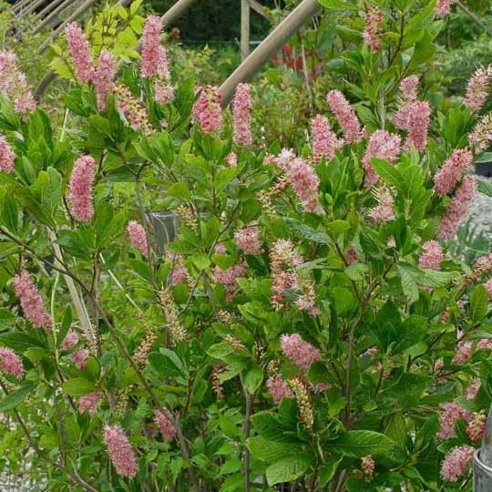
And it wasn’t all ground covers.  The forest hosts large stands of Kalmia latifolia, the native rhododendron or mountain laurel, and sweet pepperbush (Clethra alnifolia).  They’re especially lush around the kettle ponds.  Over two hours, we learned a lot of botany.
Which brings me to the real reason for this blog entry.  An old friend, sadly now deceased, accumulated enough money that organizations used to come calling asking for donations. To each one, my friend would ask one question: if your organization did not already exist, why would it be started today?
The question flummoxed many visitors because, truth be told, their missions overlapped those of dozens of other organizations.  Other non-profits had long outlived their purpose and continued on because of they were ‘brand name’ charities.  He gave to those that passed his litmus test of knowing why they were in existence, and why what they were doing was unique.
Grow Native Massachusetts is such an organization.  It is now ten years old and came into being at a time when ‘native plants’ was a marketing phrase used by the landscaping industry to foist off things that stretched the definition of ‘native’ beyond the snapping point.  Grow Native Massachusetts has the most comprehensive website on the subject of any I have seen, puts on seminars (especially Evenings with Experts but also smaller events like the one of which I was a part).  In this season of giving, it is well worth supporting.

October 7, 2017

Gardening Rocks

20,000 years ago, New England
was under a mile-thick sheet of ice
Twenty thousand years ago, New England lay under a mile-thick layer of ice.  Glaciers pushed down from the north, sculpting the land as they pushed southward as far as what is now southern Illinois.  Then, some ten thousand years ago, those glaciers gradually retreated, leaving behind terminal moraines that became Long Island and Cape Cod, and creating the Connecticut and Hudson River valleys.  Playing sand castles on some cosmic scale, glaciers gouged out the Great Lakes and New York’s Finger Lakes.

Louis Agassiz
The glaciers also occasionally ‘burped’, leaving piles of rocks in odd places.  Areas of bedrock proved to be the immovable objects against which the otherwise irresistible force of the glacier was forced to go over rather than through.  As the glacier moved, it pushed along sometimes enormous chunks of rock it had gathered from more pliable formations. 

Until the nineteenth century, the above paragraphs would have been considered something between nonsense and heresy, especially in the United States. Everyone ‘knew’ that Noah’s Flood had been responsible for the shape of lakes, rivers, and mountains.  Then, in 1837, Swiss Professor Louis Agassiz proposed the theory of glaciation.  His work caught the attention of Boston philanthropist John Amory Lowell, who induced him to emigrate to America, where the ‘Noah’s Flood’ theory was still firmly entrenched.

In the background is 'Little' Agassiz.  Double-click to see
the family at its base.
Agassiz settled at Harvard and found the New England coastal plain to be a proving ground for his theory.  Over several decades, glaciation came to be the only rational explanation for ‘errata’ like giant rocks atop hills that were hundreds of miles from their point of origin.  One of the prime examples of such ‘errata’ was a pair of rocks in Manchester-by-the-Sea, Massachusetts.  In 1874, at the end of his career, Agassiz visited the site and confirmed what his students had found: a glacier had pushed up and left behind these rocks.  The site was named for him.

On Saturday, Betty and I hiked half a mile from the nearest road to observe these rocks, which more than lived up to advance billing.  We were at the top of a prominent hill overlooking the countryside and there, in two locations, were these barn-sized rocks, the smaller of which was resting at an improbable angle.

A Google Maps view.  The white area marks the site
surrounding 'Little' Agassiz.
We were able to do this because, decades ago, someone gave a large chunk of land (which was later augmented by additional gifts) to an organization called Trustees of Reservations.  In Massachusetts, the Trustees own vast swaths of ecologically sensitive or historic land.  Their goal, stated elegantly, is to protect the region's heritage for future generations. 

The Agassiz Rocks Reservation is a rounding error in the Trustees holdings, a few hundred acres in a part of Massachusetts that has dozens of similar sites (including the Trustees’ ‘crown jewel’, Crane Beach).  While there are marked trails and an evident effort to ensure that ordinary walkers can get from the road to the rocks (and beyond), there’s no admissions gate or other barrier to entry.  On an early October day at noon, there was just one other car in the parking area.

Clethra grows wild, too
I write all this because, when the gardening season draws to a close, it is time for gardeners to go exploring new places and see what nature can teach them.  Saturday offered a few eye-opening lessons.  The first was seeing a grove of clethra surrounding ‘Big Agassiz’.  To me, clethra is a ‘suburban’ shrub; we have half a dozen compact specimens in our garden.  But there it was: an expanse of clethra growing as nature intended in a boggy area at the base of the rock.  It was, in its own way, an epiphany.

The ferns at the top of a rock
Then, there were the ferns.  Betty saw them first: they were improbably ensconced fifteen feet up at the top of an enormous rock.  The ferns were thriving where they ought to be washed away with every rainfall and erased out of existence with each winter.  Were they growing in a quarter inch of leaf litter, or had their roots found purchase in unseen crevices?


With luck, yesterday started a new season of discovery and of learning.